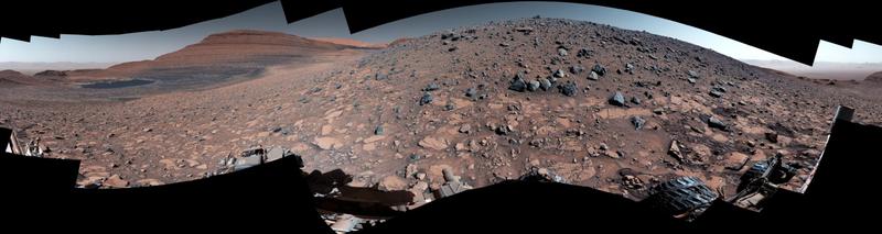
NASA's intrepid Mars Curiosity Rover has captured breathtaking 360-degree panorama from the base of Gediz Vallis Ridge that shows evidence of water on the Red Planet. This remarkable achievement comes after three previous attempts spanning three years, with the rover finally conquering the ridge on 14 August, 2023, which marked the 3,923rd Martian day, or sol, of its illustrious mission.
On 19 August, Curiosity's Mastcam embarked on a mission of its own, capturing a total of 136 individual images that were seamlessly stitched together upon their return to Earth, resulting in the captivating mosaic before us. The colours have been meticulously adjusted to emulate the lighting conditions as perceived by the human eye on our home planet.
Gediz Vallis Ridge stands as one of the last features to have taken shape on Mount Sharp, a colossal 3-mile-tall (5-kilometer-tall) mountain that Curiosity has been steadily ascending since 2014. This ridge serves as a living archive, preserving the memory of one of the final wet periods witnessed on this Martian terrain.
However, reaching this geological marvel was no easy feat. Previous attempts were thwarted by menacing "gator-back" rocks with knife-edged edges and slopes deemed too steep for the rover's capabilities. After overcoming one of the most challenging climbs in the mission's history, Curiosity spent 11 days at the ridge's base. The rover then set its sights higher up the mountain, to delve into Gediz Vallis Channel. This ancient channel, believed to have transported water some 3 billion years ago, carried with it rocks and debris that gradually accumulated to form the ridge.
Curiosity's incredible journey has been made possible by the dedicated team at NASA's Jet Propulsion Laboratory, under the stewardship of Caltech in Pasadena, California. JPL has been at the helm of this remarkable mission on behalf of NASA's Science Mission Directorate in Washington.
Where: United States
When: 19 Sep 2023
Credit: NASA/JPL-Caltech/MS
In a world where six-pack abs are flaunted more than six-point health plans, who are we really trusting with our well-being? Consultant Aesthetic and Plastic Surgeon, Dr Ali Ghanem, cuts through the noise in a candid conversation with Qonversations — unpacking the layered relationship between health, social media, influence, and longevity. Dr Ghanem, in an interview with Ismail Akwei, begins with a stark reminder: “Health is life.” He challenges the outdated definition of health as merely the absence of disease and instead argues for a reimagined standard — optimal functioning across body and mind. You may be disease-free, but if your cognitive function, mobility, or digestion isn’t thriving, you’re missing the very essence of life.
In the era of social media, post-COVID, and with mental health at the forefront, a shift is taking place in how people perceive well-being. As a new approach that looks beyond traditional medicine gains popularity, one voice stands out: Natalie Lefevre, a longevity expert whose journey from personal health struggles to keynote speaker and influencer has inspired many. “I believe we’re in a major paradigm shift,” Natalie explains. According to the health optimisation expert, who was misdiagnosed 18 years ago, conventional systems often fail to address the root causes of illness. Instead, she advocates for a proactive, investigative approach to health—one that emphasizes prevention, self-awareness, and personal responsibility.